

Data is everywhere. Businesses collect it from surveys, sensors, websites, machines, field teams, and about a hundred other places. But having a mountain of data doesn’t automatically mean you know what it is telling you. That’s where mapping and data services start to matter. They help turn scattered information into something people can actually see, understand, and use. And honestly, that last part matters most.
Why Raw Data Isn’t Enough
Raw data can be messy. Sometimes really messy.
You might have thousands of records sitting in spreadsheets, GPS coordinates in one system, images in another, and field notes buried in emails. Each piece might be useful on its own, but putting the full picture together is another job entirely.
This is where mapping becomes useful. Instead of looking at rows and rows of numbers, businesses can put information into a visual context. Suddenly, patterns that were easy to miss become pretty obvious.
Customer demand may be much higher in one area. Certain roads may be causing repeated delays. Or a group of properties shares the same environmental risk. A map can make these relationships easier to spot.
That’s the real value of mapping and data services. They don’t just organize information. They help people understand what the information means.
From Location Data to Better Decisions
Location is one of the most useful pieces of information a business can have. Where something happens can be just as important as what happens.
Think about industries like construction, agriculture, utilities, transportation, real estate, and environmental management. They all deal with physical locations every day. A spreadsheet might tell you that an asset needs maintenance. A properly built map can show exactly where that asset is, what surrounds it, and how it connects to other assets.
That changes the conversation.
Instead of asking, “What does the data say?” teams can start asking better questions. Where are problems happening most often? Which areas need attention first? What has changed since the last survey?
Good mapping and geospatial analysis can answer those questions without making people dig through endless datasets.
Better Data Collection in the Field
Of course, none of this works if the original data is poor.
Field data collection has come a long way. Survey teams can now collect location information, photographs, measurements, and other details much faster than they could years ago. Aerial technology has also made it easier to capture large areas without sending a team into every corner of a site.
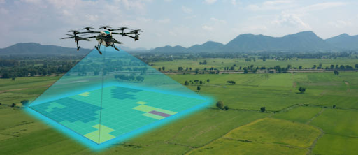
This is where UAS Hardware can become useful. Unmanned aerial systems can capture high-resolution imagery and other information across difficult or large areas. Instead of relying entirely on manual inspections, teams can gather a much broader view and then process that information for mapping and analysis.
But buying equipment isn’t the whole answer. The hardware needs to produce usable data. Flight planning, sensors, positioning, image processing, and data management all play a part. If those pieces aren’t handled properly, you can end up with a very expensive collection of files that nobody knows what to do with.
That’s why the data workflow matters just as much as the equipment.
Turning Complex Information Into Something Usable
One of the biggest challenges with modern datasets is simply volume.
More sensors. More images. More measurements. More updates.
It sounds great until someone has to manage it.
Professional mapping and data services can help clean, organize, process, and structure information so it becomes easier to work with. Depending on the project, that might involve GIS databases, digital mapping, 3D models, aerial imagery, asset inventories, or spatial analysis.
The goal isn’t to make the final product look impressive. It’s to make it useful.
A good map should answer a question. A good dataset should support a decision. If someone still needs three spreadsheets, two phone calls, and a half-day meeting to figure out what they’re looking at, something probably went wrong.
The Role of UAS Hardware in Modern Mapping
The growth of drone technology has pushed geospatial work forward pretty quickly. With the right UAS Hardware, organizations can collect detailed aerial information for surveying, inspection, monitoring, and mapping.
That doesn’t mean drones replace people. They give people better information to work with.
A drone can cover a large area in less time, capture repeat imagery, and reach places that may be awkward or unsafe for ground crews. The real advantage comes when those images are combined with other datasets.
For example, aerial imagery might be compared with existing GIS layers, property boundaries, infrastructure records, or historical surveys. That creates a much richer picture than any one dataset could provide.
And that’s where technology becomes genuinely useful, rather than just being another shiny tool.
Why Businesses Need a Clear Data Strategy
It’s tempting to treat mapping as a one-off project. Get the survey done, create the map, send the report, move on.
But data keeps changing.
Roads change. Buildings go up. Assets move. Land conditions shift. Customer behavior changes. A map that was accurate six months ago might already be missing something important.
A stronger approach is to build a repeatable data process. Collect information consistently, keep it organized, update it when needed, and make sure the people using it can actually access the results.
That’s the long-term advantage of mapping and data services. They can become part of everyday decision-making instead of sitting in a folder until someone remembers they exist.
Conclusion
Raw data has value, but raw data alone rarely tells the full story. The real opportunity comes from connecting information, putting it into context, and turning it into something people can act on.
From GIS and spatial analysis to aerial surveys and UAS Hardware, modern tools give businesses more ways to collect and understand information than ever before. But the technology itself isn’t the magic part. The process behind it is.
When data is collected properly, mapped clearly, and managed with a purpose, it becomes much more than numbers and files. It becomes insight. And that’s ultimately what mapping and data services are supposed to deliver — not more data, but a clearer way to make sense of it.